
Projects undertaken for the National Parks and Wildlife Service

Coastal Habitat Monitoring Surveys and Conservation Status Assessment
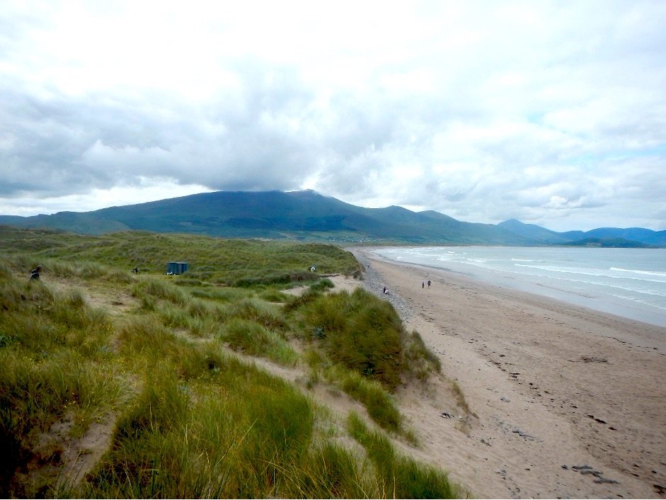
Wetland Surveys were appointed by the National Parks and Wildlife Service (NPWS) to undertake a monitoring survey of coastal habitats in southwest Ireland from 2022-2024. Coastal habitats play an extremely important role in providing ecosystem services (e.g. food provision, coastal protection, recreational opportunities, carbon storage) and supporting livelihoods. In addition, many of the species found in coastal areas are adapted to cope with high levels of salinity, drought, and windy conditions, leading to the presence of unique habitats and communities that are not found in other locations. A number of coastal habitats are listed under Annex I of the EU Habitats Directive. Every six years Ireland must monitor and report on the conservation status of these habitats to the EU as a requirement of Article 17. The current surveys will contribute to the next cycle of Article 17 reporting in 2025.
During this project, monitoring surveys of Annex I coastal habitats will be undertaken at 34 sites in southwest Ireland (Cork, Kerry, Limerick, and Clare). Surveys entail carrying out habitat mapping, collecting vegetation data (used to help determine the condition of the site), and details on impacting activities. The results of these surveys, and surveys undertaken by two other project teams in the east, west and northwest of Ireland, will be used to inform National Conservation Status Assessments to determine the current status of these important habitats in Ireland. Data collected during previous monitoring surveys will be used as a baseline to determine if changes have taken place at survey sites since the previous reporting period. Wetland Surveys will be responsible for completing the Conservation Status Assessments of five Annex I habitats: annual vegetation of drift lines (1210), embryonic shifting dunes (2110), white dunes (2120), dunes with creeping willow (2170), and humid dune slacks (2190).

Freshwater Pearl Mussel Monitoring Surveys
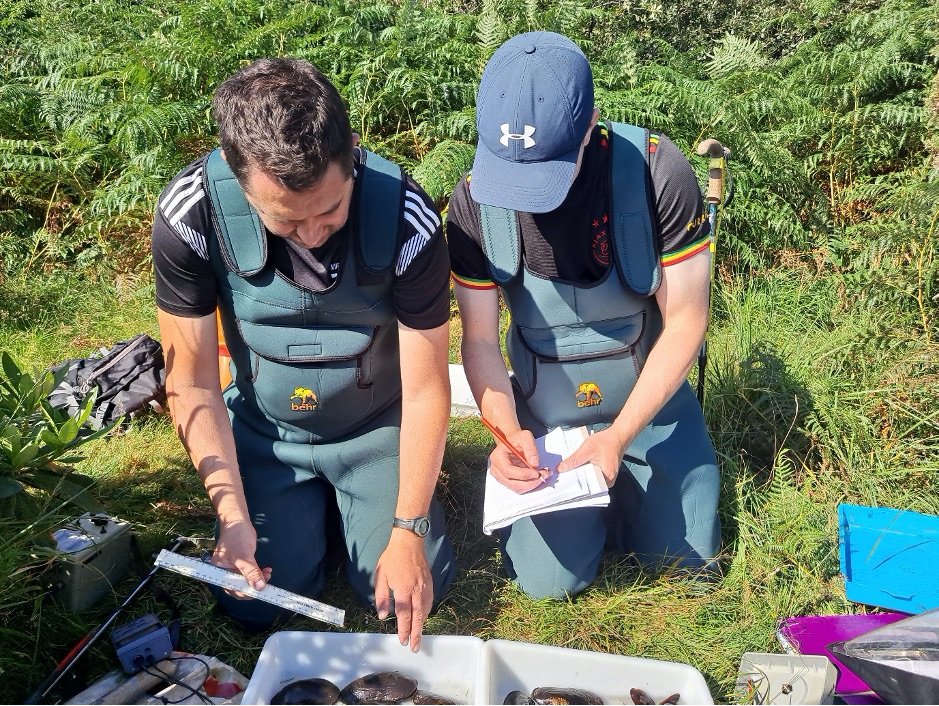
Wetland Surveys are currently undertaking monitoring and surveying of Freshwater Pearl Mussel populations in 14 catchments in Ireland for NPWS. Freshwater Pearl Mussel populations have undergone a severe decline over the past decades and the species is critically endangered in Ireland and across Europe. Freshwater Pearl Mussel are listed on Annex II and IV of EU Habitats Directive.
Remnant populations of FPM remain widespread in Ireland, a number of which have large population numbers and are of international importance. However, their populations are not currently sustainable and are at high risk of extinction. It is believed that most Irish FPM populations have not recruited successfully since the 1970s or 1980s. For favourable conservation status of a species within a Natura 2000 site to be achieved, one of the criteria is that the population dynamics data on the species should indicate that the population is maintaining itself on a long-term basis as a viable component of its natural habitats.
Monitoring of Freshwater Pearl Mussel populations has been ongoing in Ireland since 2004, partly driven by Ireland’s obligation to undertake “surveillance of the conservation status of natural habitats and species referred to in Article 2” of the EU Habitats Directive. The results of this monitoring informs the national conservation status assessment of this species. The conservation status of the Freshwater Pearl Mussel was reported to be ‘Bad and deteriorating’ under Article 17 reporting of the Habitats Directive in 2007, 2013, and 2019. The current survey work is being carried out for the 2019-2024 monitoring period. The data collected during these surveys will provide up to date information on the status of FPM populations in target catchments and will allow for a comparison with data from the previous reporting period to determine if the status of the species is deteriorating, stable, or improving.

Raised Bog Surveys and Conservation Status Assessment
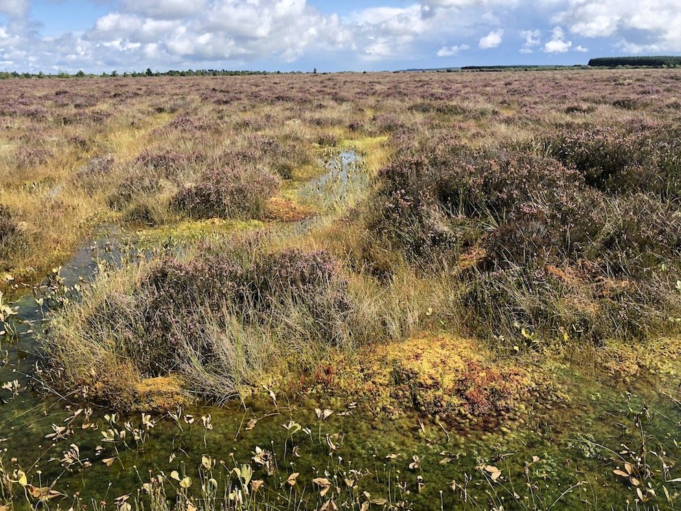
In terms of environment and biological diversity, Ireland’s raised bogs are of importance not only nationally, but they are of European and indeed global significance. In an intact state, they along with other peatlands support a range of ecosystem services such as the potential for climate regulation through carbon storage & sequestration, water filtration, recreational and educational opportunities, a repository of past climates, vegetation and human activity and possess an intrinsic biodiversity value in themselves. The current designated raised bog network consists of 53 raised bog SACs and 75 raised bog NHAs totalling an area of 17,995 ha. The legal basis on which SACs are selected and designated is the Habitats Directive while Natural Heritage Areas are designated using national legislation (the Wildlife Acts). Additional protection is afforded by the Water Framework Directive (Council Directive 2000/60/EC).
Wetland Surveys (WS) has participated in a number of national raised bog research project over the period 2013 to 2023. From 2013 to 2016 WS participated in research and undertook 49 raised bog surveys as part of the development of the National Raised Bog Special Areas of Conservation (SACs) Management Plan 2017 – 2022. This Plan was published on 21 December 2017. In 2018 Wetland Surveys conducted ecotope surveys of 21 raised bog Natural Heritage Areas to assess type and condition of raised bog habitats on these sites. The outcome of this survey informed the national raised bog conservation strategy. The project involved field ecology, GIS mapping, condition assessment and the preparation of conservation status assessment reports for the 21 bogs.
Wetland Surveys were recently appointed by NPWS to undertake monitoring survey of raised bog habitats in Ireland from 2022-2024. Every six years Ireland must monitor and report on the conservation status of raised bog habitats to the EU as a requirement of Article 17. The WS raised bog project will form the basis for reporting on raised bog habitats in 2025. During this project, monitoring surveys of raised bog habitats will be undertaken at 31 sites, with a Conservation Status Assessments (CSA) undertaken at an additional ten sites. Surveys entail carrying out habitat/ecotope mapping, quadrat vegetation data, and details on impacting activities. Data collected during previous monitoring surveys will be used as a baseline to determine if changes have taken place at sites since the previous reporting period. WS will be responsible for completing the National Conservation Status Assessments for Annex I raised bog habitats: active raised bog (7110), degraded raised bog still capable of regeneration (7120), and Depressions on peat substrates of the Rhynchosporion (7150).
Another component of the project involves assisting UCD and the EPA in the establishment of a National Ecosystems Monitoring Network (NEMN) of sites to monitor air pollution. The revised EU National Emissions Ceiling (NEC) Directive (2016/2284) requires Member States to ensure the monitoring of negative impacts of air pollution upon ecosystems based on a network of sites that is representative of their freshwater, natural and semi-natural habitats. Fifteen raised bog sites across a geographical range have been selected to be part of NEMN and WS will establish five monitoring relevés on each of these sites as well as collecting peat and vegetation samples for chemical analysis. In addition, WS are working with universities (including the Wageningen University in the Netherlands) in assisting in the development of techniques to survey raised bog habitats using Earth Observation and Remote Sensing (EORS) technologies.